Show Mobile Navigation
Powered by Blogger.
Latin
Showing posts with label Latin. Show all posts

Friday, October 24, 2014

Dean's Blue Hole, World's Deepest Blue Hole

XPlanet - 10/24/2014 08:46:00 PM
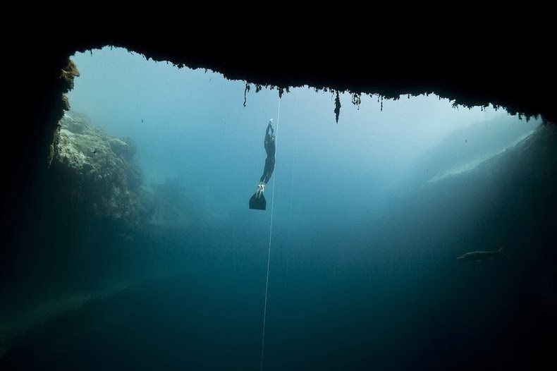
Dean's Blue Hole near Clarence Town on Long Island, Bahamas, is the world's deepest known “blue hole” - a term given to any deep, water filled, vertical caves or sinkholes with an entrance below the water surface. While most blue holes and sinkholes reach a maximum depth of 110 meters, Dean's Blue Hole plunges to more than 200 meters, which makes it quite exceptional. At the surface, Dean's Blue Hole is roughly circular, with a diameter ranging from 25 to 35 meters. After descending 20 meters, the hole widens considerably into a cavern with a diameter of 100 meters.
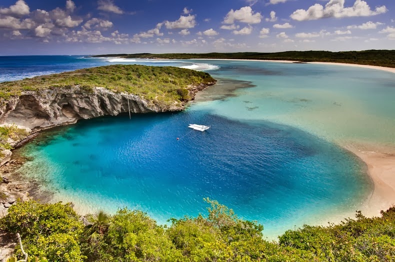
deans-blue-hole-9

Blue holes are so called for the dramatic contrast between the dark blue, deep waters of their depths and the lighter blue of the shallows around them. The intense blue color is created by high transparency of water and bright white carbonate sand. Blue light is the most enduring part of the spectrum; other parts of the spectrum - red, yellow, and green - are absorbed during their path through water, blue light manages to reach the white sand and return upon reflection.

Blue holes formed during past ice ages, when sea level was as much as 100–120 meters lower than at present. These holes were formed by deeper groundwater gradually dissolving the limestone until the ceiling of these voids collapsed. Later the sea level rose and filled the holes with water.
Dean's Blue Hole is a popular spot for diving ad snorkeling. At the 2012 freediving world cup in the Bahamas, New Zealand competitor William Trubridge set a world record when he dived to a depth of 121 meters without air in Dean’s Blue Hole.

deans-blue-hole-8
deans-blue-hole-3
deans-blue-hole-4
deans-blue-hole-1
deans-blue-hole-2
deans-blue-hole-6
deans-blue-hole-7
deans-blue-hole-5

Pacu, The Fish With Very Human Teeth

XPlanet - 10/24/2014 08:45:00 PM
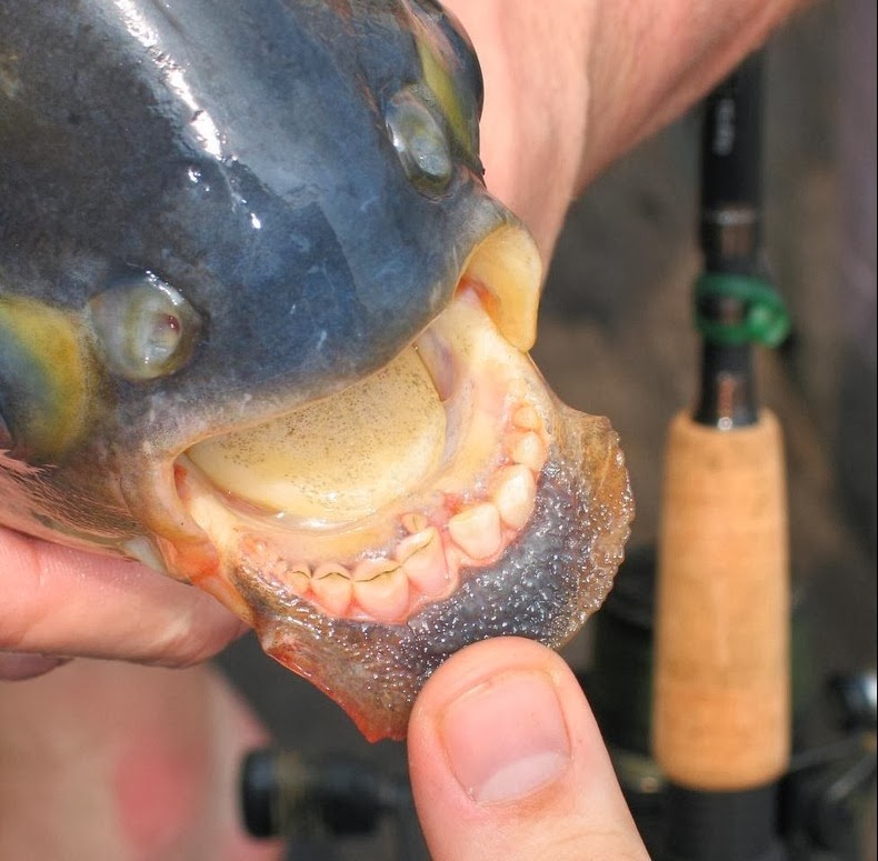
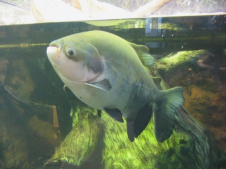
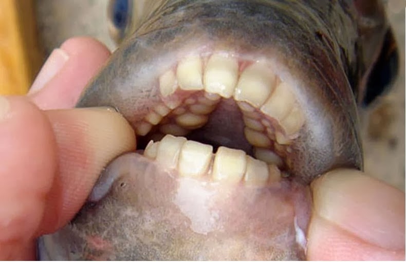
Pacu is a South American freshwater fish found in most rivers and streams in the Amazon and Orinoco river basins of lowland Amazonia, but they have also been reported as far as Papua New Guinea, where it was artificially introduced to aid the local fishing industry. Pacu is related to the meat-eating piranha, both sharing the same subfamily Serrasalminae, although they have different food habits. The piranha is a carnivorous species while the pacu is omnivorous with vegetative tendencies. The difference is evident in the structure of their teeth. Piranha have pointed, razor-sharp teeth whereas pacu have squarer, straighter teeth, that eerily resemble those of humans.

pacu-fish-6

Pacu uses its teeth mainly to crush nuts and fruits, but sometimes they also eat other fish and invertebrates. They usually eat floating fruits and nuts that drop from trees in the Amazon, and on a few occasions were reported to attack the testicles of male swimmers mistaking them to be floating nuts. This has earned them the name of "ball-cutter" after they castrated a couple of local fishermen in Papua New Guinea. So when the fish was spotted in a few odd lakes in Denmark and later in Washington, New Jersey and Illinois last year, a mild panic ensued.

While they are not aggressive carnivores like the piranha, their crushing jaw system can be hazardous. One toddler needed surgery after a pacu bit her finger at Edinburgh Butterfly and Insect World in Scotland. Commenting on the incident, Deep Sea World zoological manager Matthew Kane warned, "Pacus will eat anything, even children's wiggling fingers.

Pacus are legal to own in the United States, can be bought in aquarium stores and are easy to raise. The trouble is many aquarium owners are unaware that pacus can grow up to 4 feet long, which is way too large for a typical home aquarium. When pet pacus outgrow their fish tank, many owners end up dumping the fish in nearby lakes.

pacu-fish-1
pacu-fish-2
pacu-fish-4
pacu-fish-5
pacu-fish-7
pacu-fish-8
Aside from pacu the Sheepshead fish (Archosargus probatocephalus) also has human teeth but a little too many.
sheepshead-fish-2
Photo credit: Scientificamerican.com

A fully-grown adult sheepshead has well-defined incisors sitting at the front of the jaw, and molars set in three rows in the upper jaw and two rows in the lower jaw. It has strong, heavy grinders set in the rear of the jaw too, which are particularly important for crushing the shells of its prey. As with humans, this unique combination of teeth helps the sheepshead process a wide-ranging, omnivorous diet consisting of a variety of vertebrates, invertebrates and some plant material.

sheepshead-fish-1
sheepshead-fish-3

Sheepshead fish are also called convict fish due to the black and white bands that run down its silvery body. Photo credit

Intriguing Biodiversity at El Angel Ecological Reserve in Ecuador

XPlanet - 10/24/2014 08:31:00 PM
El Angel is a small village located in the province of Carchi, in Ecuador, approximately 170 km north of Quito and situated on the border with Colombia. The village is located in a unique type of high altitude, humid moorland called “paramo” characteristically found in the Andes of northern Ecuador and southern Colombia. The El Angel Ecological Reserve lies at nearly 12,000 to 15,600 feet above sea level and covers an area of 15,700 hectares of the paramo.

A diverse range of plants grow in this region, 60% of which are found nowhere else in the world. The most notable among them is frailejones (Espeletia pychnophyla) a giant member of the daisy family, endemic to the area. The frailejon is a treelike shrub with broad, gray-white, hairy leaves and yellow flowers, which may reach a height of up to six feet over the course of its lifetime. They cover 85% of the reserve, lending the paramo of El Angel its striking appearance and gray-green color.

el-angel-paramo-7

The Paramo of El Angel remains frigid throughout the year even though it is only 80 km from the equator. In summer months (June - September), days can be warm - up to 18 ° C, but in the winter even in daytime the temperature is around 0° C. Due to the cold weather organic remnants in paramos do not decompose - they accumulate. The moist climate turns this all into a giant natural sponge, trapping moisture deposited by the regular rains and mists and letting it out slowly into the surrounding foothills in the form of streams and small rivers, which eventually join to make up the basin of the Mira and El Angel rivers.

Plants growing in the paramo have developed specific methods to protect themselves from the cold. One method is growing in rosettes, so the wind can not chill the centre of the plant. Many plants have developed very soft, "plumy" leaves and flowers which serve as mini-sponges. In some plants the old leaves do not fall off - they enclose the stem and allow development of new roots along the stem.
The reserve is also home to numerous animals including highlights, rainbow trout, the frog marsupial, the jambato, duck dotted, the condor, gli-gli coot, moor Partridge, the curiquingues, the Andean gull, the giant heath, the Quilico, deer, dirty, wild rabbits, the Chucuri, the brocket, the fox, the buzzer and the turtle and other species.

el-angel-paramo-11
el-angel-paramo-3
el-angel-paramo-4
el-angel-paramo-5
el-angel-paramo-9
el-angel-paramo-1
el-angel-paramo-2
el-angel-paramo-6
el-angel-paramo-10

Mocona Falls: A 3 km Waterfall That Runs Parallel to The River

Unknown - 10/24/2014 06:03:00 PM
Iguazu Falls may be the most popular waterfalls in Argentina, but Mocona Falls take the crown for the most unique. Mocona does not follow the normal downward and forward trajectory that most waterfalls do. Instead, it runs along the length of the river with water spilling off the side into a gorge. At 3 km long, it is perhaps the only waterfalls in the world to run parallel to the river rather than perpendicular.

Mocona Falls, also known as Yucumã Falls, is located in the Uruguay river, in the province of Misiones, in Argentina, 337 kilometers from the city of Posadas and 322 kilometers from Iguazu Falls. Since the Uruguay river acts as a natural border between Argentina and Brazil, this unique geological feature is shared by both countries. The name Moconá means “to swallow everything” in the Guarani language and is used mostly in Argentina. Yucumã means “the big fall” and is popular in Brazil.

mocona-falls-7
An unusual feature of the Uruguay River is the presence of a submerged canyon or trench at the bottom of the river channel. The canyon, which is believed to have formed during the Ice Age, when the climate was drier and the river was narrower, is up to 100 meters deep and 15 - 30% of the width of the river. The canyon is only visible in two places, one of which is the Moconá Falls.

The falls itself are not visible for 150 days a year when the river is full. During this period, the falls become more like rapids. When water level becomes low and falls below the edge of the canyon, it starts spilling into the now exposed canyon, and the Mocona Falls is formed. Depending on the volume of the water dragged by the Uruguay River, the height of the falls varies from five to seven meters. The width of the waterfall is also subjected to water volume ranging between 1,800 meters and 3,000 meters wide.

The area where the Moconá falls are located is considered a Provincial Park which include the Yabotí Biosphere Reserve. Countless lodges have been settled down in the area which provide accommodation for visitors in search of water activities such as rubber boat rafting, canoe outings, kayaking and safaris along the river and creeks around this wetland.

mocona-falls-8
mocona-falls-9
mocona-falls-4
mocona-falls-5
mocona-falls-6
mocona-falls-1
mocona-falls-3
mocona-falls-2

The Mountains of Hornocal

Unknown - 10/24/2014 05:57:00 PM
The mountain valley of Quebrada de Humahuaca, in the province of Jujuy, in north-west Argentina, is home to some fascinating geology. The Hill of Seven Colors and Painter's Palette in Maimará are famous, but most visitors leave the creek without knowing the mountains of Hornocal or “Serranias del Hornocal”. Located just 25 km from Humahuaca, along a well-graded unpaved road, this mountain range is definitely a must-see for anyone visiting Argentina, yet quite shockingly, this site left out of almost all the tourist circuits because of which Serranias del Hornocal remains unknown to most travelers on the road that leads to Humahuaca.

mountains-of-hornocal-10

The incredible colors and the inverted-V shaped formation seen here is part of the limestone formation called Yacoraite that extends from Peru to Salta, through Bolivia and the Quebrada de Humahuaca. The road that leads to this place, located at an altitude in excess of 4,300 meters, is inaccessible by bus, but can be easily reached by a regular car or a 4x4. Despite warnings of inaccessibility and risks involved, those who travel to this place have discovered that it’s actually a pretty easy route.

mountains-of-hornocal-1
Photo credit: unknown
mountains-of-hornocal-4
mountains-of-hornocal-5
mountains-of-hornocal-6
mountains-of-hornocal-7
mountains-of-hornocal-8
mountains-of-hornocal-9
mountains-of-hornocal-2
mountains-of-hornocal-3

The Walls of Sacsayhuaman

Unknown - 10/24/2014 05:56:00 PM
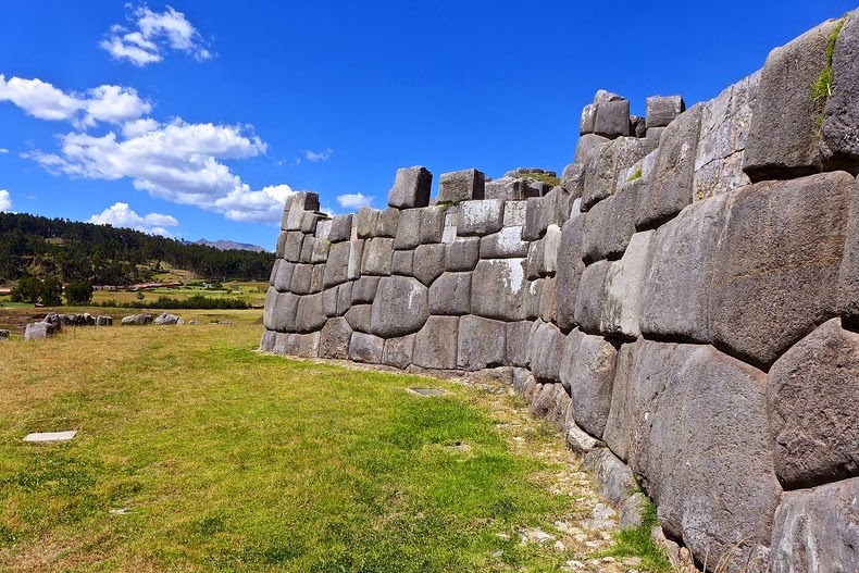
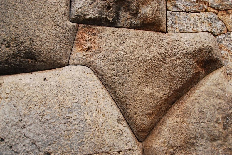
Sacsayhuaman (also spelled Saksaywaman), is one of the most stunning Inca ruins, located on the northern outskirts of the old city of Cusco, Peru, the former capital of the Inca Empire. Built like a fortress, the complex cover a huge area, but they constitute perhaps only a quarter of the original complex, which could easily house more than 10,000 men. What remains today are the astounding outer walls constructed in a zigzag formation on three levels. Like many Inca constructions, the walls are made of massive, irregularly shaped boulders that fit together like a jigsaw puzzle without the aid of mortar. The stones are so closely spaced that even a piece of paper cannot be inserted between many of the stones.

sacsayhuaman-14
Grassy pathways run between the walls and are interrupted at intervals by towering stone doorways. Above the walls are the circular foundations of three towers that once stood here. It is easy to feel dwarfed standing next to the stones. The biggest cornerstone stands 8.5 meters high. The longest of three walls is about 400 meters and stand 6 meters tall. A single boulder is estimated to weight between 120 to 200 tonnes.

The ruins of Sacsayhuaman predates the Inca themselves, believed to have been built by the Killke culture that occupied the region between 900 and 1200 AD.

Sacsayhuamán is usually described as a fortress because it is enclosed by three slopes and constructed with forbidding, castlelike walls. However, new investigation suggest that it could have been a temple devoted to the worship of the Sun. When the Spanish conquered Cusco during the 1500s, they began to tear down the structure and took off with rocks to build the new city, as well as the houses of the wealthiest Spaniards. Today, only the stones that were too large to be moved remain at the site.

sacsayhuaman-8
sacsayhuaman-10
sacsayhuaman-2
sacsayhuaman-3
sacsayhuaman-5
sacsayhuaman-1
sacsayhuaman-13
sacsayhuaman-4
sacsayhuaman-6
sacsayhuaman-7
sacsayhuaman-11

Previous
Editor's Choice