Show Mobile Navigation
Powered by Blogger.
Amazing
Showing posts with label Amazing. Show all posts

Friday, October 24, 2014

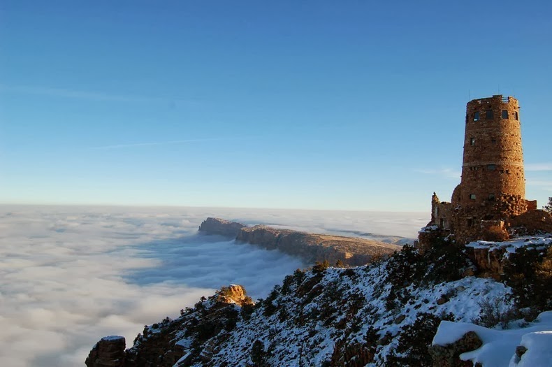
Rare Weather Phenomenon Creates River of Clouds Over Grand Canyon

XPlanet - 10/24/2014 08:48:00 PM
A rare weather phenomenon that affects the area only about once a decade, filled the Grand Canyon in the U.S. with a dense, white fog at the end of November. The phenomenon, known as "temperature inversion," happens when the temperature profile of the atmosphere is inverted from its usual state, and cooler air is trapped at the earth's surface by warmer air above.

Typically, the temperature of air in the atmosphere falls the higher up in altitude you go. This is because most of the suns energy is converted into heat at the ground, which in turn warms the air at the surface. The warm air rises in the atmosphere, where it expands and cools. When temperature inversion occurs, the temperature of air actually increases with height. The warm air above cooler air acts like a lid, trapping the cooler air and fog at the surface and preventing it from rising.

grand-canyon-fog-1

Temperature inversions happen once or twice a year, typically in the winter months. However, these inversions are partial and cover only few parts of the Grand Canyon. The most recent inversion happens only once every 10 years, because the fog filled up the entire canyon and it happened on a cloudless day.

AccuWeather.com Meteorologist Andy Mussoline explained the factors that contributed to the event.
"First, there was higher-than-normal moisture in the canyon," he said. "There was 0.75 of an inch of liquid precipitation that fell between Nov. 20 and Nov. 24 at the Grand Canyon National Park Airport [both snow and rain]. Normal precipitation during that time is only 0.19 of an inch, which converts to nearly 400 percent of normal precipitation within about a week of the event."

“Additionally, the average high temperature for this time of year is about 48 degrees Fahrenheit, which means there would be less evaporation of that precipitation than there would be in the summer months. This allowed more moisture to stay in the air inside the canyon.”

"A high pressure system settled into the region late last week and allowed for clear skies and calm winds, two important weather conditions that allow the air near the ground to cool rapidly," Mussoline said. "The rapid cooling of the ground allowed a temperature inversion to form."

grand-canyon-fog-2
grand-canyon-fog-3
grand-canyon-fog-4
grand-canyon-fog-5
grand-canyon-fog-6
grand-canyon-fog-7

Bryce Canyon National Park

Unknown - 10/24/2014 06:38:00 PM
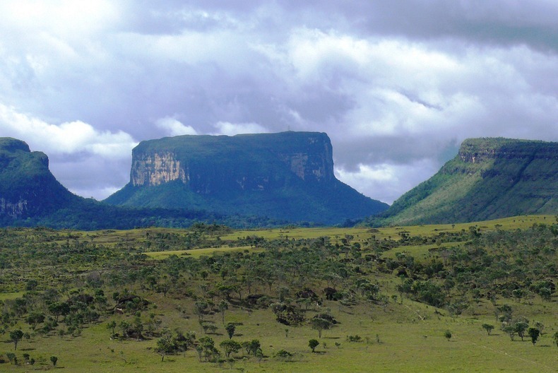
Tepuis are flat table-top mountains found in the Guayana Highlands of South America, especially in Venezuela. In the language of the Pemon people who live in the Gran Sabana, Tepui means ‘House of the Gods’ due to their height.

Tepuis tend to be found as isolated entities rather than in connected ranges, which makes them host to hundreds of endemic plant and animal species, some of which are found only on one tepui. Towering over the surrounding forest, the tepuis have almost sheer vertical flanks, and many rise as much as 1,000 meters above the surrounding jungle. The tallest of them are over 3,000 meters tall. The nearly vertical escarpments and dense rainforest bed on which these tepuis or mesa lie make them inaccessible by foot. Only three of the Gran Sabana's mountains can be reached by foot, among which the 2,180m-high Roraima is the most accessible.

tepui-venezuela-4

Tepuis are the remains of a large sandstone plateau that once covered the granite basement complex between the north border of the Amazon Basin and the Orinoco, between the Atlantic coast and the Rio Negro, during the Precambrian period. Over millions of years, the plateaus were eroded and all that were left were isolated flat-headed tepuis. Although the tepuis looks quite barren, the summit is teeming with life.

The high altitude of tepuis causes them to have a different climate from the ground forest. The top is often cooler with frequent rainfall, while the bases of the mountains have a tropical, warm and humid climate. Many extraordinary plants have adapted to the environment to form species unique to the tepui.

Some 9,400 species of higher plants have been recorded from the Venezuelan Guayana, of which 2322 are registered from the tepuis. Approximately one-third of the species occur nowhere else in the world.

There are 115 such tabletop mountains in the Gran Sabana region in the south-east of Venezuela where the highest concentration of tepuis are found. The most famous among them is Mount Roraima. Roraima, was unexplored until 1884. Today, the plateaued summit is a popular destination for backpackers and home to small waterfalls, natural quartz-lined pools and Punto Triple, the point at which the borders of Venezuela, Brazil and Guyana meet. Mount Roraima is said to have inspired the Scottish author Arthur Conan Doyle to write his novel The Lost World.

The other famous tepui is Auyantepui, home to Angel Falls, the highest waterfall in the world. Auyantepui is also the largest of the tepuis with a surface area of 700 km².

tepui-venezuela-2
tepui-venezuela-5
tepui-venezuela-6
tepui-venezuela-7
tepui-venezuela-8
tepui-venezuela-9
tepui-venezuela-1
tepui-venezuela-10
tepui-venezuela-11
tepui-venezuela-12
tepui-venezuela-13
tepui-venezuela-14
tepui-venezuela-15
tepui-venezuela-3
tepui-venezuela-16
tepui-venezuela-17
tepui-venezuela-18
tepui-venezuela-19
tepui-venezuela-20
tepui-venezuela-21

Zlatni Rat - The Golden Horn Beach, Croatia

Unknown - 10/24/2014 06:37:00 PM
The Golden Horn, also called Zlatni Rat, is the most spectacular of Croatia's beaches. This vast, golden pebble beach, almost 580 yards long, juts out into the water like a white tongue stretched into the sea. The tip of the beach changes shape and position, depending on the wind. Surrounded by pine wood and crystal clear sea, this beach stands out with its fascinating beauty.

Situated at the south eastern edge of the Croatian island Brač, near Bol, this beach became, throughout the years, the favorite spot for tourists both Croatian and foreign. The beach attracts tourists from all over the world, who enjoy the sun, the sea and water sports.

The Golden Horn offers a wide range of water sports, including jet-ski, SSI scuba-diving, banana boats, as well as parachute rides, beach volley and many other fun things. For those who just want to relax, away from the scorching sun rays, the nearby pine forest represents a perfect retreat.

Zlatni-rat-0
Zlatni-rat-1
Zlatni-rat-2
Zlatni-rat-3
Zlatni-rat-4

Krubera Cave – The World’s Deepest Cave

Unknown - 10/24/2014 06:37:00 PM
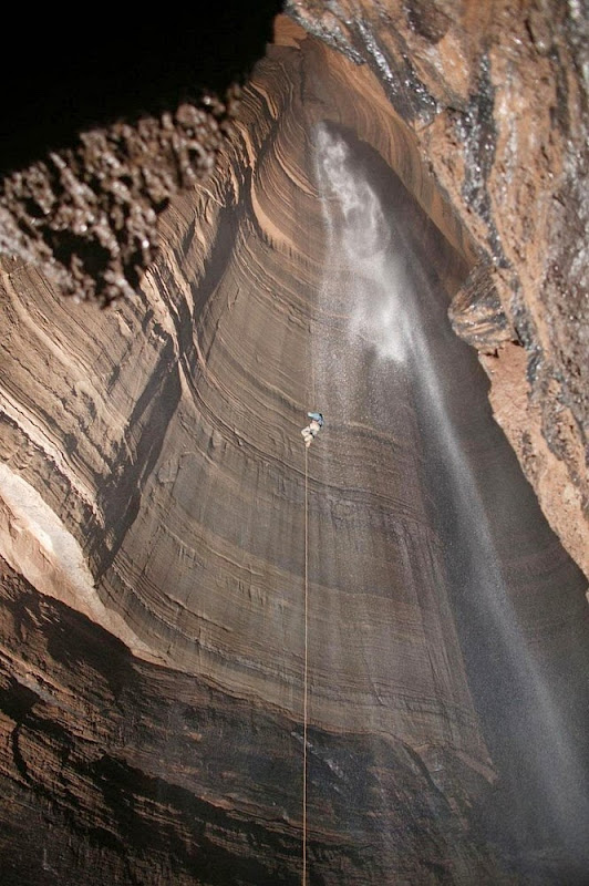
Krubera Cave, also known as Voronya Cave (Russian for “Crow’s Cave”) is the deepest known cave on Earth. It is located in the Arabika Massif, one of the largest high-mountain limestone karst massifs in the Western Caucasus region of Georgia. This mountain block contains several hundred caves that started to develop when the mountains started to rise more than 5 million years ago. Five of these caves are deeper than 1,000 meters; Krubera is 2197 meters deep and is the only known cave on Earth deeper than 2,000 meters.

Krubera Cave is a 16,058 meters long cave system which for most part consists of deep, vertical wells which are interconnected with passages. The cave starts high in the mountains, at an altitude of 2,256 meters, with a narrow entrance. Krubera Cave often is very narrow and had to be carved at many places to allow safe passage. At other places, the passageway is as large as subway tunnel.

krubera-cave-3

At the depth of 200 meters, the cave divides into two main branches: Non-Kuybyshevskaya (explored to the depth of 1,293 m in 2008) and Main (2,197 m deep). At the depth of 1,300 meters the cave further divides into numerous branches.

When speleologists started exploring the cave, one of the hardships they faced were flooded tunnels called "sumps." When they encounter a sump, cavers have to put on scuba gear and charge ahead. One of the sumps – the deepest one - has been dived up to 52 m depth.

The cave now is very popular destination for the expeditions coming from many countries.

krubera-cave-2
krubera-cave-4
krubera-cave-5
krubera-cave-6
krubera-cave-7
krubera-cave-8
krubera-cave-9
krubera-cave-10
krubera-cave-11
krubera-cave-12
krubera-cave-13
krubera-cave-1

Source: Wondermodo / Wikipedia. Photo courtesy: Avaxnews

Spectacular Lava Landscape at Hawaii Volcanoes National Park

Unknown - 10/24/2014 06:19:00 PM
Remember that game “Hot Lava” that you used to play as a child? It would be real fun and challenging to play the game at Hawaii Volcanoes National Park, because here you don’t have to pretend the floor is lava. The ground actually is lava.

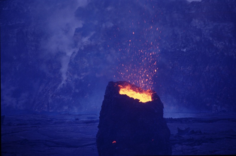
At the Hawaii Volcanoes National Park on the "Big Island" of Hawaii, you can watch the landscape change before your very eyes, thanks to Kilauea volcano, one of the most active volcanoes on earth. The park is also home to Mauna Loa, the world's most massive volcano. The park offers dramatic volcanic landscapes, flowing rivers of hot, molten lava as well as glimpses of rare flora and fauna. The chance to witness the primal process of creation and destruction make this park one of the most popular visitor attraction in Hawaii and a sacred place for Native Hawaiians.

Founded in 1916, the Park encompasses 333,000 acres from the summit of Maunaloa to the sea. Over half of the park is designated the Hawaii Volcanoes Wilderness area and provides unusual hiking and camping opportunities. Here you'll find 150 miles of hiking trails through volcanic craters, scalded deserts and rainforests as well as a museum, petroglyphs, a walk-in lava tube and two active volcanoes: Maunaloa, which last erupted in 1984 and Kilauea which has been erupting since January 3rd, 1983.

hawaii-volcanoes-park-3
Kilauea is sometimes called "the world's only drive-in volcano." This prolific volcano currently produces 250,000-650,000 cubic yards of lava per day, enough to resurface a 20-mile-long, two-lane road daily. With lava flowing at an average rate of 800-1,300 gallons per second from vents on the east rift zone of Kilauea, more than 500 acres of new land have been added to the island of Hawaii since Kilauea's eruption began on January 3, 1983.

hawaii-volcanoes-park-4
hawaii-volcanoes-park-5
hawaii-volcanoes-park-6
hawaii-volcanoes-park-8
hawaii-volcanoes-park-9
hawaii-volcanoes-park-10
hawaii-volcanoes-park-11
hawaii-volcanoes-park-16
hawaii-volcanoes-park-17
Previous
Editor's Choice