Show Mobile Navigation
Powered by Blogger.
Europe
Showing posts with label Europe. Show all posts

Friday, October 24, 2014

Curious Rock Formation of Giant's Causeway in Ireland

XPlanet - 10/24/2014 08:42:00 PM
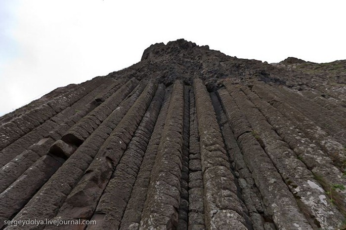
The Giant's Causeway in northeast coast of Northern Ireland, is an area of about 40,000 interlocking basalt columns, the result of an ancient volcanic eruption. The tops of the columns form stepping stones that lead from the cliff foot and disappear under the sea. Most of the columns are hexagonal, although there are also some with four, five, seven and eight sides.

giants-causeway (2)

The remarkable geological features of the region have earned it the title of the Eight Wonder of the World and established it as a major part of Ireland's heritage. For 300 years the Causeway and the cliffs of the Causeway Coast have attracted thousands of visitors from around the world. Travellers have marveled at the beauty of the formations while scientists have sought to describe and explain them.

The causeway was formed during the early Paleogene period some 50 to 60 million years ago over a long period of intense volcanic activity. Highly fluid molten basalt intruded through chalk beds to form an extensive lava plateau. As the lava cooled rapidly, contraction occurred. While contraction in the vertical direction reduced the flow thickness (without fracturing), horizontal contraction could only be accommodated by cracking throughout the flow. The extensive fracture network produced the distinctive columns seen today. The basalts were originally part of a great volcanic plateau called the Thulean Plateau which formed during the Paleogene period.

Giant's Causeway was declared a World Heritage Site by UNESCO in 1986, and a National Nature Reserve in 1987 by the Department of the Environment for Northern Ireland.

giants-causeway (1)
giants-causeway (4)
giants-causeway (5)
giants-causeway (6)
giants-causeway (8)
giants-causeway (9)
giants-causeway (10)
giants-causeway (13)
giants-causeway (17)
giants-causeway (18)
giants-causeway (3)
giants-causeway (15)

The Dark Hedges in Ireland

XPlanet - 10/24/2014 08:39:00 PM
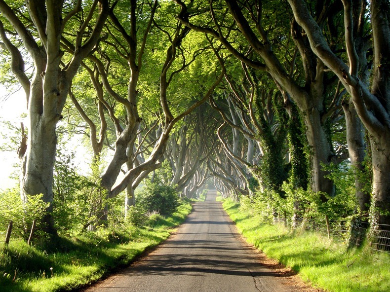
The Dark Hedges is a unique stretch of the Bregagh Road near Armoy, in Ireland, that looks like something from a Tim Burton movie. Over the past 300 years or so, the Beech trees guarding either side of the lane have reached up and across to each other, becoming heavily intertwined to create a natural arched tunnel where shadow and light plays through entwined branches.

This beautiful avenue of beech trees was planted by the Stuart family in the eighteenth century. It was intended as a compelling landscape feature to impress visitors as they approached the entrance to their Georgian mansion, Gracehill House, which is now a golf club. Two centuries later, the trees remain a magnificent sight and have become one of the most photographed natural phenomena in Northern Ireland.

Legend tells that a supernatural ‘Grey Lady’ haunts the thin ribbon of road that winds beneath the ancient beech trees. She silently glides along the roadside and vanishes as she passes the last beech tree. Some say the specter is the ghost of a maid from the nearby house who died in mysterious circumstances centuries ago. Others believe that she is a lost spirit from an abandoned graveyard that is thought to lie hidden in the fields nearby. On Halloween night, the forgotten graves are said to open and the Grey Lady is joined on her walk by the tormented souls of those who were buried beside her.

dark-hedges-2
dark-hedges-3
dark-hedges-5
dark-hedges-6
dark-hedges-8
dark-hedges-1
dark-hedges-9
dark-hedges-4
Source: VisitBallMoney

Zlatni Rat - The Golden Horn Beach, Croatia

Unknown - 10/24/2014 06:37:00 PM
The Golden Horn, also called Zlatni Rat, is the most spectacular of Croatia's beaches. This vast, golden pebble beach, almost 580 yards long, juts out into the water like a white tongue stretched into the sea. The tip of the beach changes shape and position, depending on the wind. Surrounded by pine wood and crystal clear sea, this beach stands out with its fascinating beauty.

Situated at the south eastern edge of the Croatian island Brač, near Bol, this beach became, throughout the years, the favorite spot for tourists both Croatian and foreign. The beach attracts tourists from all over the world, who enjoy the sun, the sea and water sports.

The Golden Horn offers a wide range of water sports, including jet-ski, SSI scuba-diving, banana boats, as well as parachute rides, beach volley and many other fun things. For those who just want to relax, away from the scorching sun rays, the nearby pine forest represents a perfect retreat.

Zlatni-rat-0
Zlatni-rat-1
Zlatni-rat-2
Zlatni-rat-3
Zlatni-rat-4

Unusual Rock Formations at Torcal de Antequera

Unknown - 10/24/2014 06:18:00 PM
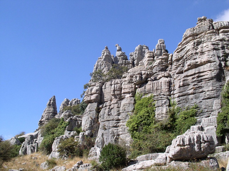
El Torcal de Antequera is a nature reserve in the Sierra del Torcal mountain range located south of the city of Antequera, in Spain. It is known for its unusual limestone formations and magnificent geology formed over millions of years. El Torcal de Antequera Nature Reserve has one of the most impressive landscapes in Europe. It’s not very far from human habitation either. The reserve can be reached via the village of Villanueva de la Concepción, just 10 kilometres from the town of Antequera, and 20 kilometres north of Málaga.

Millions of years ago the entire area of El Torcal was submerged under the ocean being part of a marine corridor that stretched from the Gulf of Cádiz to Alicante. During the Tertiary era, violent movements of the earth’s crust lifted these seabeds out of the water to an elevation of over 1300 meters, resulting in a modest mountain range of flat-lying limestone, which is rare in Andalucia. For the next 100 million years, these rocks were subjected to severe erosion by wind and rain leaving some of the most peculiarly shaped rock formations in the world today. Many of these shapes resemble, and have been named after, everyday objects such as the Sphinx, the Jug, the Camel, the Screw, etc. Other flat surfaces have been karstified into rugged, rocky lands where travel on foot is difficult.

torcal-de-antequera-4
Like many massive limestones, the Torcal includes caves and other underground forms, some of them of historical importance like the Cueva del Toro (Cave of the Bull) with its Neolithic artifacts. Their origins are also related to the dissolution of underground limestone by rainwater.

The region is bare for the most part of the year, except in spring when an explosion of coloured flowers and moss grows on the rock faces – with species such as lilies, Nazarenes, red peonies, wild rose trees and orchids blossoming – making EL Torcal a picture-postcard oasis of calm and tranquillity. Other than the rocks, El Torcal’s 17-square-foot landscape is marked with a thick green carpet of pine trees, craggy canyons and trickling streams.

The area was designated a Natural Site of National Interest in July 1929, and a Natural Park Reserve of about 17 square kilometers was created in October 1978.

torcal-de-antequera-1
torcal-de-antequera-2
torcal-de-antequera-3
torcal-de-antequera-5
torcal-de-antequera-6
torcal-de-antequera-8

Sources: 123

Skradinski buk in Croatia

Unknown - 10/24/2014 06:12:00 PM
Skradinski buk is the longest and the most popular waterfall on the Krka River and is one of Croatia’s best known natural wonders. It is a massive, clear, natural pool with high waterfalls at one end and cascades at the other. The Skradinski buk is the lowest of the three sets of waterfalls formed along the Krka river and located approximately 13 kilometers downstream from Roški slap and a total of 49 kilometers downstream from the source. The growth of travertine barriers at Skradinski buk was caused by the unification of the waters of Krka River with the three kilometer lower current of the Čikola River at Roški slap, creating one of the most unusual and beautiful landscapes of the Krka National Park.

The combined waters of the Krka and Čikola Rivers flow over the 17 steps at Skradinski buk, distributed along the 800 meters in length. The width of the cascades is between 200 and 400 metres with a total height difference of around 45 meters. Travertine formations in the lower portion has caves and tufts while the upper portion of the river include thresholds, travertine islands, draperies and barriers. A walking trail has been constructed over the river that takes visitors on a light walk through the deep shade of lush Mediterranean and sub-Mediterranean vegetation.

skradinski-buk-9
skradinski-buk-3
skradinski-buk-6
skradinski-buk-7
skradinski-buk-5
skradinski-buk-8
skradinski-buk-11
skradinski-buk-2
skradinski-buk-4

The Pseudocraters of Iceland

Unknown - 10/24/2014 06:10:00 PM
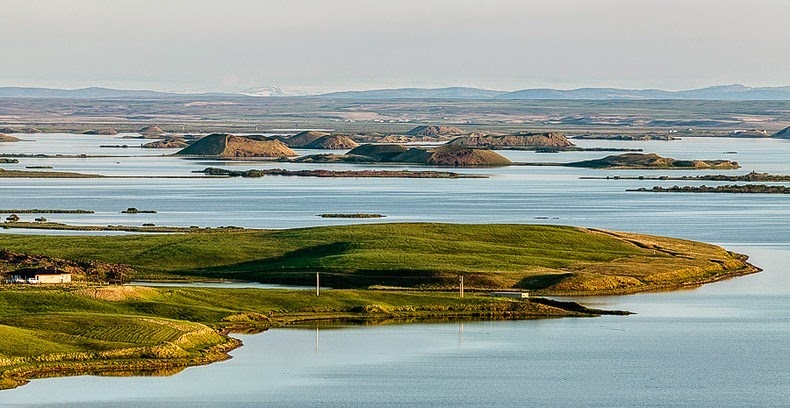
A pseudocrater looks like a true volcanic crater, but is not. These distinctive landforms are created when flowing hot lava crosses over a wet surface, such as a swamp, a lake, or a pond causing an explosion of steam through the lava. The explosive gases break through the lava surface in a manner similar to a phreatic eruption, and flying debris builds up crater-like feature which can appear very similar to real volcanic craters. Pseudocraters are also known as rootless cones, since they are characterized by the absence of any magma conduit which connects below the surface of the earth.

A classic locality for pseudocraters is the Lake Myvatn area of northern Iceland that was formed 2,300 years ago by basaltic lava eruption. The lava flowed down the Laxárdalur Valley to the lowland plain of Aðaldalur where it entered the Arctic Ocean about 50 km away from Mývatn. There was a large lake in the area at the time, a precursor of the present-day Mývatn. When the glowing lava encountered the lake some of the water-logged lake sediment was trapped underneath it. The ensuing steam explosions tore the lava into small pieces which were thrown up into the air, together with some of the lake.

pseudocrater-7
By repeated explosions in a number of locations, groups of craters built up and now dominate the landscape on the shore of Lake Mývatn and also form some of the islands in the lake. The Myvatn pseudocraters occur in several groups around the lake and as islands within the lake. A group of such craters at Skútustaðir on the south shore of the lake is protected as a natural monument and is frequented by tourists. Other pseudocrater groups in this lava field are in the Laxárdalur Valley and Alftaver district. Pseudocraters have also been discovered in the Athabasca Valles region of Mars, where lava flows superheated groundwater in the underlying rocks.

pseudocrater-5
pseudocrater-6
pseudocrater-11
pseudocrater-12
pseudocrater-2
pseudocrater-3
pseudocrater-4
pseudocrater-8
pseudocrater-9
pseudocrater-10

Previous
Editor's Choice