Show Mobile Navigation
Powered by Blogger.
Lake
Showing posts with label Lake. Show all posts

Friday, October 24, 2014

Guelta d’Archei, a Surprising Oasis in Chad

Unknown - 10/24/2014 05:48:00 PM
Guelta d'Archei is an oasis, or rather a guelta, in the heart of the Sahara desert. A guelta is a peculiar type of wetland, typical of desert regions, formed when underground water in lowland depressions spills to the surface and creates permanent pools and reservoirs. Guelta d'Archei is located in the Ennedi Plateau, in north-eastern Chad, hidden behind a canyon. Its waters sheltered by the towering sandstone cliffs typical of this region. Everyday, hundreds of camels are herded into the knee deep water of the guelta by passing caravans for them to drink and rest. Dung from thousands of camels excreted over hundreds of years have turned the water black.

Lurking in the black waters is a small group of surviving Nile crocodiles, a vestige of a wetter time when this species once thrived across most of today's Sahara desert and in swamps and rivers along South Mediterranean shores. Guelta d’Archei represents one of the last remaining colonies of the Nile crocodile known in the Sahara today. The crocodiles feed on fish that survive on the algae that thrive on the waters fertilized by camel droppings. Guelta d’Archei is indeed a zoological marvel.

guelta-archei-1

Up on the cliffs are rock paintings, dating back to middle Holocene, that stand testament to the guelta’s long age.

Guelta d'Archei is a barren place, away from beaten paths. Reaching it requires a 4x4 and at least four days' travel from n'Djamena, the capital of Chad. From there, a trek of a few hours will take you to the place seen in these pictures.

guelta-archei-12
guelta-archei-2
guelta-archei-3
guelta-archei-4
guelta-archei-6
guelta-archei-7
guelta-archei-8
guelta-archei-9
guelta-archei-10
guelta-archei-11
Sources: Wikipedia / Nat Geo

The Deep Blue Lakes of Band-e-Amir, Afghanistan

Unknown - 10/24/2014 05:47:00 PM
The name Afghanistan invokes images of a dry and arid country with mountainous terrain, endless desert, thorn bushes and mud houses. But at the center of this depressing landscape is a series of spectacular lakes with water so blue that it looks almost like ink.

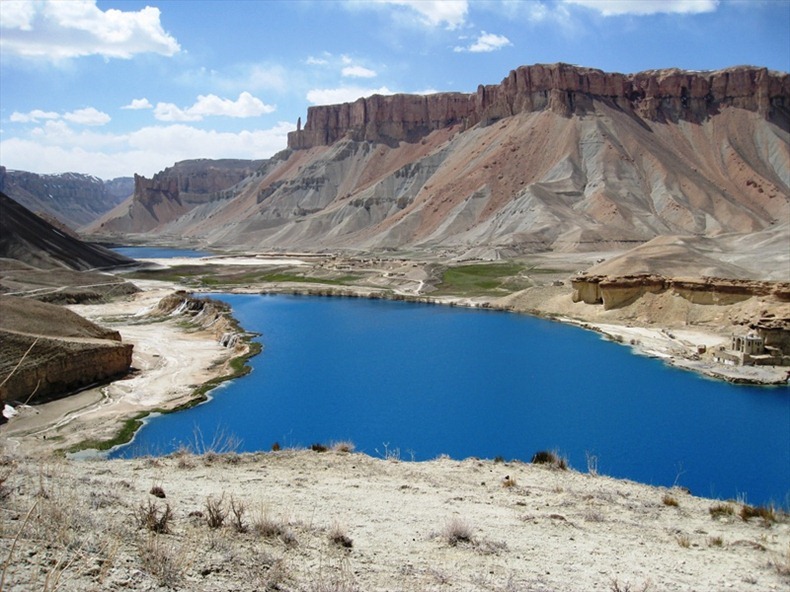
Band-e Amir is a series of six incredibly deep blue lakes in the heart of the central Afghanistan. The lakes are situated in the foothills of the Hindu Kush, the second highest mountain range in the world, 80 kilometers from the ancient town of Bamiyan, where the Taliban destroyed the world’s tallest Buddha statues in 2001. Surrounded by pink towering limestone cliffs almost in complete lack of vegetation, the stunning lakes seems totally out of place.

The beautiful lakes were created by the carbon dioxide rich water that is drawn from the spring melt-water in the surrounding mountains and came out from faults and cracks in the rocky landscape. This outflow of water percolates slowly through the underlying limestone, dissolving its principal mineral, calcium carbonate. Over time, the water deposited layers of hardened mineral (travertine), which created dams that trap water in increasingly large basins. These dams are usually about 10m high and 3m wide. Water cascades from one lake to the other near travertine terraces serving as massive natural dams between the lakes.

band-e-amir-6

The deep blue color of the lakes is due to the clarity of the air as well as the purity of the water. The high mineral content of the lakes also causes the intense and varying colors of the lake waters.
Of the six lakes, Band-e Panir is the smallest, with a diameter of approximately 100m (330ft). The largest is Band-e Zulfiqar, which measures some 6.5km (4mi) in length. The most accessible of the lakes is Band-e-Haibat, literally translated as Dam of Awe.

Band-e-Amir had been a destination for travelers since the 1950s. The lakes became a national park only in 2009, although their beauty was recognized much earlier, in 196o. But due to the instability of the government at that time, it wasn't recognized as a national park. Covering approximately 230 square miles, Band-e Amir is Afghanistan’s first and only national park and it also features on UNESCO World heritage list.

band-e-amir-14
band-e-amir-4
band-e-amir-7
band-e-amir-15
band-e-amir-5
band-e-amir-9
band-e-amir-10
band-e-amir-11
band-e-amir-13
band-e-amir-3

Lakes of Ounianga, Sahara Desert

Unknown - 10/24/2014 05:46:00 PM
The Lakes of Ounianga consist of 18 lakes located in the heart of the Sahara Desert, in an extremely arid region of northern Chad where the average yearly rainfall is no more than 2 mm. They depend on an underground supply of ‘fossil’ water that fell on this area in ancient times when the Saharan climate was much wetter than it is today. Approximately 14,800 to 5,500 years ago the area was occupied by a single large lake, probably tens of kilometers long. As the climate dried out during the subsequent millennia, the lake shrank, and large, wind-driven sand dunes invaded the original depression, dividing it into several smaller basins. The 18 lakes is all that remains today.

The lakes are situated in a shallow basin below sandstone cliffs and hills, from where the ancient water flows. The almost-year-round northeast winds and cloudless skies make for very high evaporation rates. But the underground bed of water-rich rocks are large enough to keep supplying the small lakes with water despite the high evaporation rate. Remarkably, this unique hydrological system is able to sustain the largest permanent freshwater lakes to be found in such an arid desert environment anywhere in the world.

lakes-of-ounianga-0
A NASA image taken on November 14, 2009, by the crew of the ISS.

The lakes are divided into two groups, 40km apart. They vary greatly in chemical composition, some being so salty that they can only support the most basic forms of life, while others are fresh enough to provide habitat for aquatic plants, fish and a diversity of other species. The largest and most biologically important lake (Lake Teli, in the eastern group known as Ounianga Serir) has a surface area of 4.4km2 and a maximum depth of 10 m. Its water is fresh, and supports an abundance of life. The sandy substrate is highly porous, so water flows freely underground between Lake Teli and 13 other smaller lakes in the eastern group.

Further west, across the dunes and sandstone ridges that characterise this part of the Sahara, the second group of four lakes (known as Ounianga Kebir) is found, dominated by Lake Yoan (3.6 km2 and 27 m deep). This is a hyper saline lake which supports only algae and a few other micro-organisms. Rocks around its shores are encrusted in white salt deposits, and a sprawling village of some 9,000 people is spread amongst the nearby hills and dunes.

The lakes of Ounianga form as exceptional natural landscape of great beauty with striking colours and shapes. Because of its remote location, only a trickle of fearless tourists (about 500 annually) finds its way to this remote corner of Chad.

lakes-of-ounianga-6
lakes-of-ounianga-2
lakes-of-ounianga-3
lakes-of-ounianga-4
lakes-of-ounianga-5
lakes-of-ounianga-7
lakes-of-ounianga-8

Previous
Editor's Choice