Show Mobile Navigation
Powered by Blogger.
Africa
Showing posts with label Africa. Show all posts

Tuesday, November 4, 2014

Richat Structure: Eye Of The Sahara

XPlanet - 11/04/2014 01:37:00 AM
The Richat Structure, also known as the Eye of the Sahara, is a prominent circular feature in the Sahara desert of west–central Mauritania near Ouadane. Surrounded by thousands of square miles of nearly featureless desert, this 40-50 km in diameter series of concentric circles is readily visible from space. This prominent circular feature in the Sahara desert has attracted attention since the earliest space missions because it looks like a gigantic bull’s-eye.

Richat Structure is not the site of an ancient meteor crater, as many people originally postulated. These concentric circles are actually alternating layers of sedimentary, metamorphic, and igneous rocks that were pushed upward in a symmetrical anticline, geologic dome, from below due to a small incursion of magma. The structure is a deeply eroded. The sedimentary rock exposed in this dome range in age from Late Proterozoic (2.5 billion years) within the center of the dome to Ordovician (480 million years) sandstone around its edges.

Initially interpreted as an asteroid impact structure because of its high degree of circularity, it is now argued to be a highly symmetrical and deeply eroded geologic dome. Despite extensive field and laboratory studies, geologists have found a lack of any credible evidence for shock metamorphism or any type of deformation indicative of an extraterrestrial impact.

richat-structure-6

In addition, the Richat structure lacks the annular depression that characterize large extraterrestrial impact structures of this size. Also, it is quite different from large extraterrestrial impact structures in that the sedimentary strata comprising this structure is remarkably intact and "orderly" and lacking in overturned, steeply dipping strata or disoriented blocks. A more recent multianalytical study on the Richat megabreccias concluded that carbonates within the silica-rich megabreccias were created by low-temperature hydrothermal waters, and that the structure requires special protection and further investigation of its origin.

richat-structure-3
richat-structure-2
richat-structure-4

richat-structure-5

Friday, October 24, 2014

Richat Structure: Eye Of The Sahara

XPlanet - 10/24/2014 08:40:00 PM
The Richat Structure, also known as the Eye of the Sahara, is a prominent circular feature in the Sahara desert of west–central Mauritania near Ouadane. Surrounded by thousands of square miles of nearly featureless desert, this 40-50 km in diameter series of concentric circles is readily visible from space. This prominent circular feature in the Sahara desert has attracted attention since the earliest space missions because it looks like a gigantic bull’s-eye.

Richat Structure is not the site of an ancient meteor crater, as many people originally postulated. These concentric circles are actually alternating layers of sedimentary, metamorphic, and igneous rocks that were pushed upward in a symmetrical anticline, geologic dome, from below due to a small incursion of magma. The structure is a deeply eroded. The sedimentary rock exposed in this dome range in age from Late Proterozoic (2.5 billion years) within the center of the dome to Ordovician (480 million years) sandstone around its edges.

Initially interpreted as an asteroid impact structure because of its high degree of circularity, it is now argued to be a highly symmetrical and deeply eroded geologic dome. Despite extensive field and laboratory studies, geologists have found a lack of any credible evidence for shock metamorphism or any type of deformation indicative of an extraterrestrial impact.

richat-structure-6

In addition, the Richat structure lacks the annular depression that characterize large extraterrestrial impact structures of this size. Also, it is quite different from large extraterrestrial impact structures in that the sedimentary strata comprising this structure is remarkably intact and "orderly" and lacking in overturned, steeply dipping strata or disoriented blocks. A more recent multianalytical study on the Richat megabreccias concluded that carbonates within the silica-rich megabreccias were created by low-temperature hydrothermal waters, and that the structure requires special protection and further investigation of its origin.

richat-structure-3
richat-structure-2
richat-structure-4
richat-structure-5
richat-structure-1

Sources: 12

Tsingy: The Stone Forest of Madagascar

Unknown - 10/24/2014 06:00:00 PM
Tsingy de Bemaraha Strict Nature Reserve is located close to the western coast of Madagascar. This 666 square kilometer region has been classified as a UNESCO World Heritage Site in 1990 because of its unique, breathtaking geography, preserved mangrove forests, and wild bird and lemur populations.

12

The Tsingy rise up to 70 meters from the ground. At these heights, the tops are bare and razor sharp. At lesser heights, one gets to see vegetations with roots tens of meters below.

The word tsingy is indigenous to the Malagasy language as a description of the karst badlands of Madagascar. The word which translates into English as “where one cannot walk barefoot”, aptly describes the exceptional topography. This topography of eroded limestone may exist in other areas around the world, but nowhere as tall, slender and extensive as the spires here. Beneath this apparent austerity, an extraordinary world of forest canyons, humid caves and burning karst karren is inhabited by fundamentally differing plants and animals who thrive in close proximity.

2
3
4
5
6
7
8
10
11 
13
15
16
17
18
19
20
21
22

Photos: Stephen Alvarez

Seven Coloured Earths, Mauritius

Unknown - 10/24/2014 05:51:00 PM
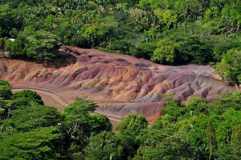
The Seven Coloured Earths, a small region near the village of Chamarel, Mauritius, is a geological curiosity and a major tourist attraction of Mauritius. This relatively small area of about 7,500 square meters comprises of sand dunes of seven distinct colours (approximately red, brown, violet, green, blue, purple and yellow).

The sands were formed from the decomposition of volcanic rock (basalt) gullies into clay, further transformed into ferralitic soil by total hydrolysis (chemical break- down of minerals by water). The two main elements of the resulting soil, iron and aluminium, are responsible for red/anthracite and blue/purplish colours respectively. The different shades of colour are believed to be a consequence of the molten volcanic rock cooling down at different external temperatures.

An unusual property of the sands is that they settle in different layers even if mixed together that gives the dunes a surrealistic, striped colouring. This strange phenomenon can be observed even on a smaller scale, if one takes a handful of sands of different colours and mixes them together, they'll eventually separate into a layered spectrum. The cause of their consistent spontaneous separation is yet to be explained. Another interesting feature of Chamarel's Coloured Earths is that the dunes seemingly never erode, in spite of Mauritius' torrential, tropical rains.

seven-colored-earths-6

The place has become one of Mauritius' main tourist attractions since the 1960s. Previously, visitors wee allowed to walk between the sand dunes when visiting the park. Nowadays, the dunes are protected by a wooden fence and visitors are not allowed to climb on them, although they can look at the scenery from observation outposts placed along the fence. Curio shops in the area sell small test-tubes filled up with the coloured earths.

seven-colored-earths-7
seven-colored-earths-0
seven-colored-earths-1
seven-colored-earths-2
seven-colored-earths-3
seven-colored-earths-4
seven-colored-earths-5

Guelta d’Archei, a Surprising Oasis in Chad

Unknown - 10/24/2014 05:48:00 PM
Guelta d'Archei is an oasis, or rather a guelta, in the heart of the Sahara desert. A guelta is a peculiar type of wetland, typical of desert regions, formed when underground water in lowland depressions spills to the surface and creates permanent pools and reservoirs. Guelta d'Archei is located in the Ennedi Plateau, in north-eastern Chad, hidden behind a canyon. Its waters sheltered by the towering sandstone cliffs typical of this region. Everyday, hundreds of camels are herded into the knee deep water of the guelta by passing caravans for them to drink and rest. Dung from thousands of camels excreted over hundreds of years have turned the water black.

Lurking in the black waters is a small group of surviving Nile crocodiles, a vestige of a wetter time when this species once thrived across most of today's Sahara desert and in swamps and rivers along South Mediterranean shores. Guelta d’Archei represents one of the last remaining colonies of the Nile crocodile known in the Sahara today. The crocodiles feed on fish that survive on the algae that thrive on the waters fertilized by camel droppings. Guelta d’Archei is indeed a zoological marvel.

guelta-archei-1

Up on the cliffs are rock paintings, dating back to middle Holocene, that stand testament to the guelta’s long age.

Guelta d'Archei is a barren place, away from beaten paths. Reaching it requires a 4x4 and at least four days' travel from n'Djamena, the capital of Chad. From there, a trek of a few hours will take you to the place seen in these pictures.

guelta-archei-12
guelta-archei-2
guelta-archei-3
guelta-archei-4
guelta-archei-6
guelta-archei-7
guelta-archei-8
guelta-archei-9
guelta-archei-10
guelta-archei-11
Sources: Wikipedia / Nat Geo

Lakes of Ounianga, Sahara Desert

Unknown - 10/24/2014 05:46:00 PM
The Lakes of Ounianga consist of 18 lakes located in the heart of the Sahara Desert, in an extremely arid region of northern Chad where the average yearly rainfall is no more than 2 mm. They depend on an underground supply of ‘fossil’ water that fell on this area in ancient times when the Saharan climate was much wetter than it is today. Approximately 14,800 to 5,500 years ago the area was occupied by a single large lake, probably tens of kilometers long. As the climate dried out during the subsequent millennia, the lake shrank, and large, wind-driven sand dunes invaded the original depression, dividing it into several smaller basins. The 18 lakes is all that remains today.

The lakes are situated in a shallow basin below sandstone cliffs and hills, from where the ancient water flows. The almost-year-round northeast winds and cloudless skies make for very high evaporation rates. But the underground bed of water-rich rocks are large enough to keep supplying the small lakes with water despite the high evaporation rate. Remarkably, this unique hydrological system is able to sustain the largest permanent freshwater lakes to be found in such an arid desert environment anywhere in the world.

lakes-of-ounianga-0
A NASA image taken on November 14, 2009, by the crew of the ISS.

The lakes are divided into two groups, 40km apart. They vary greatly in chemical composition, some being so salty that they can only support the most basic forms of life, while others are fresh enough to provide habitat for aquatic plants, fish and a diversity of other species. The largest and most biologically important lake (Lake Teli, in the eastern group known as Ounianga Serir) has a surface area of 4.4km2 and a maximum depth of 10 m. Its water is fresh, and supports an abundance of life. The sandy substrate is highly porous, so water flows freely underground between Lake Teli and 13 other smaller lakes in the eastern group.

Further west, across the dunes and sandstone ridges that characterise this part of the Sahara, the second group of four lakes (known as Ounianga Kebir) is found, dominated by Lake Yoan (3.6 km2 and 27 m deep). This is a hyper saline lake which supports only algae and a few other micro-organisms. Rocks around its shores are encrusted in white salt deposits, and a sprawling village of some 9,000 people is spread amongst the nearby hills and dunes.

The lakes of Ounianga form as exceptional natural landscape of great beauty with striking colours and shapes. Because of its remote location, only a trickle of fearless tourists (about 500 annually) finds its way to this remote corner of Chad.

lakes-of-ounianga-6
lakes-of-ounianga-2
lakes-of-ounianga-3
lakes-of-ounianga-4
lakes-of-ounianga-5
lakes-of-ounianga-7
lakes-of-ounianga-8

Previous
Editor's Choice